The City of Norwalk s developing an urban waterfront land use plan, including areas near the Carver Community Center. See the timeline for the project below. Let the Planning & Zoning Department have the benefit of your feedback on this planning!
Click here to go to see the different scenarios for each of the five districts within the study area. Click on each district to share your opinion on which land use and zoning scenario you think is best for the City of Norwalk and what public benefits you would prioritize in that area. You can also use the "drag to comment" icons to make more site-specific comments about places where there are tensions between different land uses and areas where there is an opportunity to invest in beneficial environmental and infrastructural projects.
This map below shows the boundary of the Waterfront Plan area and also highlights the relationship of different parcels to the planning process:
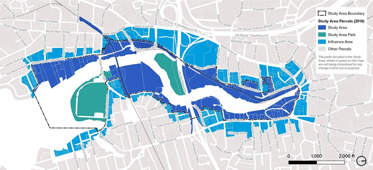
Study Area (shown in dark blue): will be examined to determine if a change in land use and zoning regulations is appropriate.
Study Area Parks (shown in green): public parks within the study area will remain as-is, but are included in the plan because surrounding land uses need to be complementary to them in order to create a positive experience for park users and minimize conflicting objectives.
Influence Areas (shown in light blue): these lay just outside of the study area boundary and will not be considered for any changes in land use and zoning regulations as part of this plan. They will be analyzed, however, to make sure that any changes proposed within the study area are compatible with the uses and character within these Influence Areas.
Urban waterfronts serve many purposes – they are centers for economic activity that are dependent on the water and are desirable spaces for public recreation. They are also sought-after locations for housing and commercial uses like restaurants and retail. Waterfronts must also respond to many pressures and changes such as rapidly evolving economic conditions and increased flood risk.
In Norwalk, our Harbor Plan prioritizes water-dependent uses. The current waterfront includes a number of long-standing industrial and marine commercial properties that add to Norwalk’s maritime character.
This plan will help Norwalk to take stock of the needs, aspirations, and ideas for the future of the city’s waterfront. The result will be a framework for regulations, rezoning recommendations, and projects needed to pursue a healthy, vibrant, and dynamic waterfront for Norwalk that balances public access, water-dependent land uses, water quality, and flood resiliency.
